Fortifications in Ancient India
A. Cunningham and his associates, between 1862 and 1885, have identified several locations of buried fortified sites. British archaeologists at the beginning of the 20th century, followed by Indians from the twenties onwards, were mainly concerned with the Copper and Bronze Age. This is the reason why so many Harappan sites in Pakistan and in Western India have been systematically excavated and also why early historic sites did not attract the attention of scholars with the same eagerness.
2It is true that the task is not an easy one. Vestiges of ramparts are
buried under enormous amounts of debris corresponding to different periods of
construction and, moreover, enclosures have undergone modifications through the
centuries, which make the restoration of the original structures very
difficult.
- 4 G.R. Sharma, Excavations
at Kausambi, 1957-59. M.S. Mate, in ‘Early Historic
Fortifications in the (...)
3The excavations have often been partial, limited, and the outcome has
been of varying quality. The recent reports, particularly those which concern
the early historic period are generally mere accounts, with a few plans,
forcing us to use the old drawings of fortified towns published by Cunningham
and his associates at the end of the 19th century. Even the systematic and
comprehensive publications pay more attention to the stratigraphy, the
classification of layers and strata than to the specific characteristics of the
defence sites (archaeologists are not necessarily experts in military
technology and architecture!). The most typical example is the detailed report
by G.R. Sharma on Kausambi, one of the best excavated sites in India, in which
there is no general plan of the site, no drawing of the gate described, no
mention of the curtain walls and towers, or of the location and spacing of the
salients; the section in the rampart shows only the outside revetment and the
late additions.4 It is therefore difficult to give a consistent, systematic
presentation of the ancient military works.
4However, in this section based on the study of 30 sites (8 from the
Harappan period, 22 from Early Historical India), an attempt is made to analyse
the main features of some ancient Indian fortifications.
5Two phases are to be considered: the first one, from the third to the
first millennium corresponding to the brilliant urban development of the
Harappan civilisation; the second, from the middle of the first millennium to
the historical period, representing what is called “the second urban
revolution” in India.
6The body of material at present available on the fortified cities of the
Harappan period, which are all located to the north-east of the subcontinent,
is entirely based on the results of archaeological excavations.
7The plans of the cities show that their layout usually consisted of two
distinct parts: on the one hand, the actual urban zone; on the other hand, the
citadel, generally located at a higher level, whose defensive works varied
depending on the sites.
8a. In the Indus valley, both settlements were separated.
- 5 EIA, vol.
II, pp. 194-196; B.K. Thapar, ‘Synthesis of the Multiple Data as obtained
from Kalibangan (...)
9- At Kalibangan, the city is divided in two parts, both quadrangular (of
8.64 ha and 2.88 ha respectively), surrounded by mud brick enclosures. The
lower city is enclosed by a wall strengthened by rectangular towers at the
comers. The citadel, consists of two parts reinforced, at regular intervals, by
rectangular towers.5 (see fig. 2, a).
10- At Harappa and Mohenjo Daro, the citadel only is surrounded by a wall.
This is an enormous bund built up of mud and debris with a nucleus of mud
brick.
- 6 R.E.M. Wheeler,
‘Harappa 1946: The Defences and Cemeteries’, Ancient India, No.
3, January 1947, pp (...)
11In the first site, having the shape of a parallelogram of 400 x 200 m
roughly (i.e. slightly less than 8 ha), the enclosure, made of a bund on which
stood the main wall, 12 m thick at its base and 10 m high, was externally
revetted with a baked brick facing and reinforced by rectangular towers higher
than the curtain walls, representing an elaborate system of enfilade6 (see fig. 2, b).

Fig. 1. Map of the fortified sites.
- 7 J.M. Casal, op.cit., pp.
100-103.
12In the second one is also found an immense bund revetted with mud brick,
12 m wide and 4 m high. At its south-east corner, a gate flanked by two towers
of baked brick has been exposed.7
13b. In the Harappan settlements of Gujarat, unlike those of the Indus
valley, city and citadel are both enclosed by the same wall.
- 8 EIA, vol. II,
pp. 257-260; S.R. Rao, Lothal 1955-62, vol. I, pp.
135-136 and pl. XXXVIII.
14- At Lothal, a massive mud wall, reinforced by baked brick walls on the
northern side encompasses a 12 ha quadrilateral area in which three high
platforms represent the acropolis, but there is no salient8 (see fig. 2, c).
- 9 EIA, vol.
II, pp. 424-425; J.P. Joshi, ‘Excavations at Surkotada’, in D.P. Agrawal
& A. Gosh, op.ci (...)
15- At Surkotada, the township was a single unit, divided into two equal
parts: the residential area and the citadel; the enclosure, rectangular in
shape and covering 0.86 ha, is made not only of mud and mud brick but also of
rubble. It is a massive wall, with a basal width of 7 m and a height of 4.5 m,
flanked by quadrangular towers at the comer and pierced by intricate entrances9 (see fig. 2, d).
- 10 EIA, vol.
II, pp. 119-121 IAR, 1963-64, pp. 10-12 and pl. VII.
16- Slightly larger (1.30 ha), the settlement of Desalpur is enclosed by a
wall having a basal width of 4 m and rising to an extent height of 2.5 m, with
a veneer of sandstone blocks on its outer and inner sides, and defended, at the
comers, by square towers.10
- 11 J.W.A. Fairservis, The
Roots of Ancient India, pp. 179-182.
- 12 EIA, vol.
II, pp. 45-46; R.S. Bisht, ‘Excavations at Banawali 1974-77’, in G.L.
Possehl, Harappan C (...)
17- The same type of defensive work is found at some other sites, such as
Kot Diji11 or Banavali.12 At the latter place, where an extensive squarish tower has been
exposed, the wall is from 5.40 m to 7.50 m wide.
- 13 The following
paragraph is principally based on the observations made by Arun Kesarwani,
‘Harappan (...)
18The enclosure walls were pierced by elaborately designed gateways.13
19-At Kalibangan (fig. 2, a & 3, a), the citadel area
is divided into two parts by a partition wall. In the northern half three
entrances flanked by a tower were exposed; in the southern portion, there were
two only: the southern one, located between two towers, is a simple 2.60 m broad
passage without guardrooms (fig. 3, a, 1), the other one,
located on the partition wall flanked by two towers is approached from the
north by a broad stairway (fig. 3, a, 3).
20In the lower city, two gateways have been found; on the western side it
is a passage, 5 m broad, provided with a guardroom (fig. 3, a, 2), to
the north-west, the entrance leads to two streets (fig. 3, a, 4).
21- At Harappa (fig. 2, b
& 3, b), the northern gateway looks like a gap in the
fortification: it was just a simple entrance without guardroom (fig. 2,
b); the gates exposed to the west (fig. 3, b, 1, 2, 3) are
all situated in a curved part of the wall: the first one (b, 1) is
a narrow passageway which leads to a stair, the second is provided with a
guardroom where door sockets are seen (h, 2) and the third,
the most complete (b, 3), forms a long entrance turning
sharply towards the south.
22- At Surkotada, one of the most important Harappan settlements, two
gateways, made of mud and mud brick, both located on the southern face of the
enclosure, are particularly elaborate and significant (figs. 2, d &
3, d): the first one, to the west, leading to the citadel (jig.
3, d, 1), forms a complex with a 10 x 23 m projection, provided with a
stairway and two guardrooms on either side; the second (fig. 3, d, 2), to
the east, used for communication with the residential area, consists of a wide
passage with two rectangular structures believed to be guardrooms on both
sides.
23- At Mohenjo-Daro and Lothal, no well-built gateways have so far been
found, except in the latter one, where there is a simple oblique opening in the
southern wall.
Assessment of the Defence System
24a. It is difficult to determine the actual function of these edifices
for various reasons. It should be noted, first, that, in several sites, because
of limited excavations, many structures have not been subject to adequate
probing and that, therefore, very little is known about the exact plan of the
constructions, the precise shape and size of the works. Moreover, it should not
be forgotten that, as the walls exposed have been rebuilt time and again, we
often ignore the exact nature of the enclosures during a particular period.
- 14 Ibid.
25Most of the archaeologists do not consider these constructions to be
defensive works, but regard them either as protective embankments against
floods or as structures erected for social functions.14
- 15 K.M. Srivastava (‘The
Myth of Aryan Invasion of Harappan Towns’, in op.cit., p.
439) thinks that th (...)
26They reckon that, at Surkotada, the gates were neither strong enough nor
elaborate enough to serve the needs of armed defence, that those found at
Kalibangan may have been used as ceremonial pathways or for commercial traffic
or were ordinary entrances for the free movement of people and goods and that
the long entrances to Harappa fort were used for official formalities,
religious or secular and served as processional ways. Thus, they want us to
believe that these enclosures had mainly a social function.15
27Regarding Lothal and Mohenjo-Daro, they all agree that the walls were
built for the protection of the town from floods.
28b. Now, it is obvious that, at the last two sites, the massive walls of
the enclosures were mainly protective bunds, safeguards from the regular
inundation of the area. It is also possible that the location of the different
gates bore some relation to the daily lives of the people (control of traffic,
human and animal movement, processions). But, these factors do not explain
fully why such massive ramparts were erected.

Fig. 2. Harappan Fortifications (A), Enclosures: a, after B.K. Thapar,
in D. Agrawal & A. Gosh, Radiocarbon and Indian Archaeology, p.
268; b, after R.E.M. Wheeler, in Ancient India, No. 3, pl. XV;
c, after S.R. Rao, Lothal 1955-62, vol. I, pl. XXXVII; d,
after J. P. Joshi, in D. Agrawal & A. Gosh, op. cit., p.
178. Note the plans quadrilateral in shape and the quadrangular towers

Fig. 3. Harappan Fortifications (B), Gates: a, b, d (after A. Kesarwani,
in B.B. Lai & S.P. Gupta, Frontiers of the Indus civilisation, figs.
7.4, 7.5). Note the flights of steps through the gates.
29If the interpretations given above are correct, then, why were the walls
reinforced by a regular series of massive towers or salients with elaborately
designed gateways? (at Banavali, the enormous walls are provided with extensive
square towers, some of them near the openings). These projecting portions of
the rampart, particularly at the comer, are not merely buttresses; they were
built to ensure the permanent flanking of the curtain walls.
30From this observation it can be inferred that the enclosures of the
cities were erected for the purpose of strengthening the human settlements
against a possible intrusion by wild animals, marauders and particularly an
offensive military operation. In places liable to the overflow of a great body
of water, these defensive structures were reinforced and also served as
protective embankments.
31Thus, in Harappan sites, are found the earliest features of a defence
system in the Indian subcontinent, i.e. massive enclosures, built of mud brick
or rubble and usually revetted with baked brick, quadrilateral in form, flanked
by quadrangular towers, a design which was adopted and perfected by the
builders of strong places during the early historic period.
B. Early Historic Fortifications
- 16 A. Gosh, The
City in Early Historical India, pp. 2, 11, 51, 61, 62-67, 80-81,
90.
- 17 M.S. Mate, op.cit., pp.
58. Regarding the rising of an urban civilisation and the growth of
fortifi (...)
32After this period there was a chronological and cultural void followed
by an intense building activity initiated in the middle of the first
millennium, sometimes regarded as the “second urban revolution”.16 For fortifications it is a significant period, particularly around
600 B.C. and also in the years 200-100 B.C., after the decomposition of the
Mauryan empire and the advent of regional principalities. At that time could be
seen «the rebirth of military architecture» in the Indian subcontinent17: the fortified cities which have been excavated are not only citadels
or walls enclosing limited residential areas, as in the Harappan period, but
large human complexes taking advantage of the defensive potentialities of
natural sites.
33a. To study them we depend essentially on the investigations carried out
by archaeologists in the different sites (though, in many cases, detailed
excavation reports are not available). For our analysis we have selected 22
significant sites. A list and short description of each one of them is given,
along with bibliographical references, in the appendix (the numbers within
brackets which follow the names of strongholds in our demonstration - example
Kausambi (No. 8) - refer to the numbers of this list).
34b. To these sources may be added literary and iconographie data.
- 18 A. Ray, Villages,
Towns and Secular Buildings in Ancient India, c. 150 B.C - 250 A.D., pp.
46-63, n (...)
35Cities and their enclosures are abundantly described in ancient
literature.18
- 19 See R.S. Betai, A
Reconstruction of the original interpretations of the Manusmṛti.
- 20 Devī Purāṇa, ch.
72, 11.42-44; Agni Purāṇa, ch. 106,
11.8-10; Matsya Purāṇa, ch. 217,
11.24-28.
- 21 Arthaśāstra, II,
3; see The Kautiliya Arthaśāstra, ed. R.P. Kangle.
- 22 Mānasollāsa, ch.
II, si. 544-584, cd. G.K. Shrigondekar.
- 23 Mānasāra, an
Encyclopaedia of Hindu Architecture, ed. P.K.
Acharya, vol. VII, pp. 226-229.
- 24 Mayamata, X, 36-61,
ed. B. Dagens, Mayamata, 1st Part, pp. 152, 160-170. This
information has been (...)
36The technical treaties on architecture and urbanism generally devote at
least a chapter to the erection of fortifications. Besides the Manusmṛti19 and the Parāṇa,20 the old treatises which give the most details are the Arthaśātra21 and works of this category (Mānasollāsa22 etc.), as well as the treatises on architecture or Śilpaśātra, such
as the Mānasāra23 or the Mayamata24
37The descriptions given in these books are to a great extent
conventional; they are found with variants in most of the books dealing with
urban centres where, for example, the specifications suggested by the Arthaśāstra are
reproduced. Thus, the descriptions given by them sound rather theoretical.
- 25 In the bas-reliefs of
Amaravati, Bodhgaya, Mathura, Nagarjunakonda, Sanchi, as well as those
found (...)
38Iconographic representations, almost entirely Buddhist (2nd c. B.C. -
4th c. A.D.),25 shed some light on the stereotyped descriptions of the ancient
texts, because they show, in a simplified but probably faithful manner, urban
constructions and particularly the superstructures of the defensive works, not
found in the vestiges exposed by the archaeological excavations.
39The history of the different sites considered here will be given in the
appendix. Let us now try to classify them. Of the numerous old classifications
proposed by the technical treatises on the urban settlements, we keep in mind
those that have been selected according to the sites, then to the layout. They
are the most commonly mentioned.
- 26 Arthaśāstra, II,
3.1; Mayamata, X, 36-38.
- 27 Arthaśāstra II,
3.21.
40The first classification distinguishes the mountain forts (giridurga,
pārvatadurga), the water forts (jaladurga, audakadurga), the
forest forts (vanadurga), the desert forts (dhānvanadurga,
irinadurga).26 The first two (i.e. those located on the slopes or on the top of a
mountain or near a water surface) are considered to be the best situated to
defend large human settlements.27
41The fortified towns exposed by excavations are often situated on flat
land, at a low or mean altitude, with hillocks or rocky outcrops, such as
Ahichchatra (No. 1) or Sankisa (No. 14) in Uttar Pradesh (fig. 8, a
& b), or they are found close to protective elongated eminences,
such as Sirsukh (No. 18) in Panjab, or near a hill slope, such as Sirkap (No.
17) (fig. 10), or also in more abrupt places where the walls
follow a chain of hills surrounding a flat basin, such as Rajgir (No. 12) in
Bihar (fig. 9).
42But most of them are located on the terraces bordering a stream course,
large or small, because of the defensive value offered by this natural
obstacle. This is the case, in the Ganges valley, with Mathura (No. 9) (fig.
5, a) and Kausambi (No. 8) (fig. 4, a), on the
Yamuna, with Sravasti (No. 20), on an old arm of the Rapti (fig. 5, b); in
Orissa, it is also the case with Sisupalgarh (No. 19), on a branch of the delta
of the Mahanadi (fig. 7, c); in Madhya Pradesh, with Ujjain
(No. 21), on the Sipra (fig. 7, a), with Besnagar (No. 4), on
the Betva (fig. 4, b) or with Eran (No. 6), on the Bina (fig.
6, a); in Andhra Pradesh, with Nagarjunakonda (No. 10), on the Krishna (fig.
6, b) or Satanikota (No. 16), on the Tungabhadra; in Karnataka, with
Banavasi (No. 12), on the Varada, and Sannati (No. 15), on the Bhima.
43Mathura and Sravasti are both located on the concave bank of meander
which forms the longest side of the strongholds (fig. 5, a & b). Besnagar
stands at the head of confluence of two rivers surrounding the settlement on
three sides (fig. 4, b), which is also the case with Eran
wedged in the loop of a meander (fig. 6, a).
44The other reason for this choice are the facilities offered by this
continuous flow to supply the ditches with water. It is the case at Sisupalgarh
(No. 19) where a river has been diverted on to the ditches of the enclosure (fig.
7, c), at Kausambi (No. 8), where the old side ditches correspond to
the streams which flow into the river (fig. 4, a), finally, at
Ujjain (No. 21), where the two arms of the ditch are connected with the river
for water supply (fig. 7, a).
- 28 Mayamata, X,
13-14.
- 29 Mayamata, X,
42-43. According to Devī-Ayni Kālikā Purāṇa, it seems that
square or rectangular forms (...)
45Regarding the plans of enclosures, the Śilpaśāstra distinguish
several types of rampart: square (caturaśra), rectangular (āyataśra), round (vṛtta), elliptical (vṛttāyata) or perfectly circular (golavṛtta)28, triangular (trikoṇa), octogonal (astāśṭra) or semicircular (nemikhaṇḍa).29
46The vestiges exposed during excavations are almost always geometrical:
an irregular polygon at Ujjain (No. 21) (fig. 7, a) and at
Sirkap (No. 17) (fig. 10), various quadrilaterals at Rajgir
(No. 12) (fig. 9), a kind of trapezium at Kausambi (No. 8) (fig.
4, a), a parallelogram at Sirsukh (No. 18) (fig. 10), a
rectangle at Vaisali (No. 22) (fig. 7, b), a square at
Sisupalgarh (No. 19) (fig. 7, c), an
isosceles triangle at Ahichchatra (No. 1) (fig. 8, b), or it
is a circular or rather oval plan at Sankisa (No. 14) (fig. 8, a), at
Banavasi (No. 2), semicircular at Sravasti (No. 20) (fig. 5, b) and
Sannati (No. 15), crescent-shaped at Mathura (No. 9) (fig. 5, a).

Fig. 4. a. River front site, trapezoid in shape, 322 ha (after CSR, vol.
I. pl. XLVIII, f.p.301); b, confluence head site, oval in shape, 176 ha (after CSR, vol.
X, pl. XII).

Fig. 5. a, River front site, crescent-shaped, 370 ha (after EIA, vol.
II, p. 284); b, river site, semicircular in shape, 150 ha, Nausahra Gate shown
(after ASI-AR, 1907-08, f.p. 80).

Fig. 6. a. River front site, mango-shaped, 15 ha, late Medieval
fortification represented (after CSR, vol. X, pl. XXIII; b,
river site, polygonal in shape, 50 ha, western gate shown (after IAR, 1957-58,
p. 7). Note that there are no salients.

Fig. 7. a, River Iront site, polygonal in shape, 100 ha (after IAR, 1956-57,
p. 21); b, flat land site, rectangular in shape, 12.5 ha (after ASl-
AR, 1903-04, f.p. 88); c. river site, square in shape, 132 ha, western
gate shown (after Ancient India, No. 5, fig. 1, f.p. 66, pl.
XXVII).

Fig. 8. a, Flat land site with rocky outcrops, oval in shape, 265 ha,
citadel in the middle (after CSR, vol. I, pl. XLV, f.p. 271);
b, flat land site with hillocks, 169 ha (after CSR, vol. I,
pl. XLIII, f.p. 257). Note that the fortifications represented are of a
later period.

Fig. 9. Rajgir: dissected hill tract site, enclosures forming irregular
quadrilaterals around old and new Rajgir, 200 ha and26 ha respectively (after ASI-
AR, 1905-06, f.p. 86).

Fig. 10. Sirkap: hill slope site, forming an irregular polygon, 73 ha; note
the pentagonal towers at the corners; Sirsukh, flat land site, forming
a parallelogram, 134 ha; note the semicircular towers (after
J. Marshall, A Guide to Taxila, f.p. 132). The layout
of the fortifications of Sirkap has been corrected according to the map given
by A. Gosh in Ancient India, No. 4, f.p. 84.
47What were the characteristics of these enclosures?
- 30 Arthaśāstra, II,
3; Mayamata, 36-48.
48From the ancient technical treatises three main features of the defence
system have to be considered:30 the rampart-ditch, the flanking towers and the gates.
- 31 Kautilya (Arthaśāstra, II,
3) mentions expressly that the rampart (vapra) must be
built with the pi (...)
49- first, the rampart-ditch, prākāra-parikhā, which
results from the same operation, i.e. the digging of an excavation in the
ground, the earth from which is thrown up behind to serve as an embankment,31 strengthened by a wall;
50- then, the projecting parts of the rampart forming quadrangular towers,
attached at regular intervals to the main enclosure, often accessible by stairs
or a ramp;
51- finally, the monumental gates, whose number is often mentioned
(generally there is one in the middle of each face and sometimes more).
- 32 “That the moat and
rampart were the results of the same operation, namely the heaping up of
the mat (...)
52Excavations confirm the treatises. What the ancient texts say regarding
a high and thick bund corresponding to a deep and broad ditch is seen in the
section through the defensive system of Ujjain (fig. 11). The
diggings carried out in other sites32 also testify to this dichotomy, except in places where it was not
needed.

Fig. 11. Dichotomy ditch-rampart: the Ujjain example (after IAR,
1956-57. p. 22).
53The embankments, then, were simply raised and strengthened by masonry
works to become true ramparts, revetted with brick or stone, better adapted to
the military technology of the time. The ditches were provided with water
coming from periodical rains or neighbouring rivers through canals.
54Most of these works, requiring an immense labour, were gigantic. It is
therefore not surprising that they had an extraordinary longevity, having been
modified and even rebuilt several times.
55Figure 11 shows how archaeologists
have been able to identify the different levels of the succeeding deposits and
to recreate the evolution of the sites. At Ujjain (No. 21) precisely,
excavations have revealed a continuous occupation from the 7th century B.C. to
the Muslim period in Malwa, i.e. until the 14th century A.D. (roughly 2000
years!). At Kausambi (No. 8), the history of the fortifications can be followed
from the second millennium B.C. to the 6th century A.D!
56Many of these fortifications cover huge areas of more than 100 ha (370 à
Mathura (No. 9), 320 at Kausambi (No. 8), 200 for the inner enclosure of Rajgir
(No. 12) and in almost all the strongholds the same character of massiveness is
found.
57Walls in all the places are bulky. In the alluvial plains, where stone
is scarce, especially along the river banks, it seems (though their dimensions
are often not given in the excavation reports) that, at their base at least,
they were roughly 30 m in width: 33 m at Sisupalgarh (No. 19), 34 m at
Nagarjunakonda (No. 10), 45 m at Eran (No. 6). At Ujjain (No. 21) (fig. 7, a), the
rampart is 74 m thick on its western side and 105 m on the riverside where it
is reinforced by wooden logs and sleepers. These embankments are generally
revetted with brick, several metres thick, with a strong batter (at Kausambi
(No. 8), it is 15° and 40°).
58In other sites, where stone is abundant, walls made of stone blocks
separated by earth and nibble filling are of a lesser thickness: from 4.2 to 5
m at Rajgir (No. 12) (fig. 14), from 4.5 to 6.4 m at Sirkap
(No. 17) (fig. 12). 4.4 m at Sirsukh (No. 18) (fig.
13), 3.2 m at Satanikota (No. 16).
59In all these sites the curtain walls are solid, i.e. having the interior
completely filled up, except at Sirsukh (fig. 13), where they
are pierced by loopholes
60On the salients or projecting outward works flanking the curtain walls
many obscure points remain because of the inadequacy of the excavations and
also owing to the rudimentatry descriptions given by archaeologists.
- 33 Arthaśāstra, II,
3, 7, 10; Mayamata, X, 13-16, 44-46.
61Classical treatises maintain that ramparts were broken by rectangular
towers, separated by spaces of 30 daṇḍa or about 60 m.33 However, they seem to be missing in some fortresses, such as
Nagarjunakonda (No. 10), where serious excavations have been conducted, or at
Banavasi (No. 2).
62In fact, in the reports published on the enclosures of earth revetted
with brick, quadrangular towers are mentioned only at Kausambi (No. 8) where
they are attached to the curtain walls, at regular intervals, and yet their
dimensions are not given. At Katragarh (No. 7), two watch-towers, one
accessible by stairs were found. It is likely that systematic excavations
conducted at other sites would reveal the existence of such works. At
Sisupalgarh (No. 19) (fig. 7, c), heaps of debris at the four
comers appear to be the vestiges of towers.

Fig. 12. Sirkap: solid rectangular towers on the curtain walls,
pentagonal towers at the comers (after A. Gosh, op.cit., f.p.
84); north gate shown (after J. Marshall, Taxila, vol.
III, pl. 10).

Fig. 13. Sirsukh: curtain walls with loopholes, hollow semicircular
towers (after J. Marshall, op.cit., vol. III, pl. 42.

Fig. 14. Rajgir: curtain walls and rectangular towers on the ridge
(photo by M.H. Kuraishi & A. Gosh, op.cit., cover).

Fig. 15. Pataliputra: double wall made of wooden sleepers thought to be
a part of the palisade seen by Megasthenes (after ASI- AR, 1926-27,
pl. XXX, c and d).
63In the stone enclosures in Bihar or Panjab, on the other hand,
projecting towers have been well preserved. At Rajgir (No. 12) (fig.
14), on the outer enclosure, there remain 16 rectangular towers, with
a salient of 10 to 12 m and a width of 14 to 18 m. At Sirkap (No. 17) (fig.
12), towers flanking irregularly the rampart project 5 m and are 7.7 m
wide; those at the comers are pentagonal in shape with a salient of 20 m and a
width of 15 m.
64As for Sirsukh (No. 18) (fig. 13), the curtain walls
are flanked, at intervals of 37 m, by towers, semicircular in plan, accessible
from the interior by means of a narrow passage carried out through the
thickness of the wall. These towers are hollow within instead of solid, and are
furnished with loopholes placed at a height of 1.5 m above the floor level.
65We should also be reminded that Pataliputra (No. 11) was protected by a
high fence made of heavy wooden sleepers placed vertically in a double row,
thought to be the wooden palisade seen by Megasthenes
66Thus, except in the North-West of the Indian subcontinent and at
Pataliputra, in all the other excavated sites in India, massive ramparts,
flanked by solid quadrangular towers, are found.
67In the defence system, openings through the enclosures appear to have
been the chief concern of the builders, for gates are very elaborate, with
defensive outworks.
68Most of the gaps made in the ancient earthen embankments (when they are
not the work of erosion) correspond to holes permitting passage through them,
but, for want of stratigraphical trenches perpendicular to the rampart, it is
difficult to determine how they were built.
69- At Nagarjunakonda (No. 10), in the valley of the Krishna, the western
gate (fig. 6, b) forms a rectangular courtyard whose
projecting part outwards is pierced by a corridor, 5 m wide; it was provided,
on both sides, with guardrooms.
70- At Satanikota (No. 16), on the Tungabhadra, an elaborate gateway,
facing south, was exposed; it is characterized by a flight of 5 steps, with a
width of 3 m, flanked by a running parapet partly of baked bricks and of
stones; significant are two pairs of sockets cut into blocks of stone,
distributed evenly on either side of the gate: the first set inside the gate
was carved to carry two leaves of the door; another set was found on either
side of the outer edge of the gateway, probably meant for the heavy posts of a
draw-bridge.
71- At Kausambi (No. 8), in the Ganges valley, the eastern gateway is
protected by a mud bund, 106 m long, which served as a curtain for the
entrance, and also two towers at the top of the rampart facing an outer tower;
situated on the other side of an extensive moat, 144 m wide! It is unfortunate
that we do not have a plan of this structure because it appears to be a
carefully laid out defence complex
72The best examples of elaborate gateways, of which we have precise plans,
are found at Sravasti, Sisupalgarh and Sirkap.

Fig. 16. Sravasti: Nausahra Gate, double curve inwards so as to form two
salients at both sides (after ASI-AR, 1901-08, pl. XXXI, f.p.
112).

Fig. 17. Sisupalgarh: west gateway, long and narrow passageway
positioned between two rectangular blocks (after Ancient India, No.
5, p. 76, fig. 4).
- 34 The same system
existed in Burma where a double curve inwards in the rampart is also
found. At Sri (...)
73- The Nausahra Gate, one of the main entrances of Sravasti (No. 20) (fig.
16) is made of a double curve inwards,34 so as to form two quadrangular brick structures, leaving between a
space of 18 m; this opening is reinforced outside by two projecting
quadrangular walls, 10 m long, on both sides of the curves; in the interior,
are two rectangular rooms enclosed by solid walls serving as guardrooms, in
which iron clamps and nails probably used in the vanished wooden doors of the
gateway were found.
74- At Sisupalgarh (No. 19) (Jig. 17), it is not an
inward but an outward structure that is found. The excavated western gateway,
built of large slabs of dressed latente, is an imposing complex comprising an
outwork made of two massive L-shaped structures, 8.4 m thick (the length of the
longer arm of the L is 48 m, that of the shorter 19 m); between these two
walls, is a long passageway, 8 m wide, leading to the interior of the fort
through two separate entrances: the outer one and the inner one, provided, at
the origin, with wooden doors, as can be inferred from the sockets found at
both places; behind the outer entrance there was a guardroom in the southern
flank, while the northern flank, near the inner gate, was pierced by a narrow
ancillary passage for pedestrian traffic; the top of the flanks could be
ascended, inside the curtain wall, by flights of stone steps at the end and on
either side of this long corridor. It is indeed a remarkably elaborate
structure.
75- In the northern gateway of Sirkap (fig. 12), the
first opening, parallel to the main wall, leads to a courtyard (18.6 m x 10.5
m), forming a kind of barbican; to the west of this open area, and
communicating with it, are two guardrooms, located on the inner and outer faces
of the rampart; worthy of note is the fact that the outer opening of the
courtyard is not set directly opposite the main street, but a little to the
east: it means that the inner entrance was masked from view and that it could
check any sudden rush of the assailant, a feature which will be adopted later
and perfected.
76We ignore the shape of the gates in other sites, but probably they were
similar to those just described, perhaps with some regional variations in
features.
77What emerges from the few examples given supra is that
gateways are no more simple rectangular openings in the plan of the curtain
walls, they are now large and complex structures, skilfully designed, situated
at the far end of a narrow bend in the curtain walls (Sravasti), where the
attackers are vulnerable to the projectiles of the defenders; forming
protruding double walls forcing the assailant to enter a corridor
(Sisupalgarh), where they are under fire from both sides with open courts or
corridors defended by guardrooms; or provided with entrances purposely not
aligned (Sirkap), so as to block the attack of an enemy rushing through such a
passage.
78With the adoption of the principle of double flanking, the gates have
become major pieces in the defence system.
79Unfortunately archaeological evidence is incomplete. Vestiges exposed
represent a kind of ground plan only, with no information on the parts of the
fortifications above their basement, which is a serious deficiency for a
military architecture principally based on the high command of the defence
system.
80What was the original height of the enclosures? Were the ramparts and
the towers crowned with a parapet? And if so, were they provided with
battlements and projecting galleries?
81We shall answer these questions by referring to ancient treatises and
analysing the iconographic data.
- 35 Arthaśāstra, II,
3.7, 10; Mayamata, X, 13-16, 44-46.
- 36 Arthaśāstra, II,
3, 7; Śukranītī, I, 1.479.
82Technical treatises shed little light on the superstructures. The
information they give on how fortifications should be erected is incomplete and
varies from book to book. Regarding the dimensions of defence works, for
instance, the figures given for the height of the ramparts vary from 12 to 24 hasta (from
6 to 12 m).35 Crenellations are not specifically mentioned, except in the Arthaśāstra, where
it is said that the top of the ramparts should be “crowned with (merlons in the
form of) drums and monkey heads”.36
- 37 See, supra, note
24.
- 38 We have tried to reproduce
faithfully, though in a simplified manner, the defence works
represented (...)
83On the other hand, the narrative of the bas-reliefs made around the
Christian era give us representations of fortified towns which appear to
correspond to the vestiges analysed by us.37 Obviously, the sculptors of the Bodhgaya, Sanchi, Nagarjunakonda
or Amaravati schools show the massive works of the peninsula and the Gandhara
artists, the strongholds of the North-West.38
Military Works Represented on the Great Stupas of the
Peninsula
- 39 Examples of plastered
masonry or dressed stones at the basement of buildings are found at
Bodhgaya (...)
84The fortifications shown in the great Buddhist monuments of peninsular
India (figs. 18, c, d, e, 19, a, c, d, 20, b)39 seem to be brick structures, a building material exposed in
excavations made in alluvial zones. The height of the ramparts appears to be
that prescribed by the texts, i.e. from 6 to 12 m. At the top of the enclosure,
the parapet is sometimes a simple wall, without any openings at Amaravati (fig.
19, c), but, in most cases, it is crenellated with serrated merlons at
Sanchi (fig. 18, b, c), rectangular merlons put close together
at Sanchi and Mathura (figs. 18, d, 20, a), or widely spaced
at Amaravati and Nagarjunakonda (fig. 19, b, d, e).
85The ramparts seem solid, because no loopholes are seen on the curtain
walls and parapets.
86At Bodhgaya are represented two parallel barriers consisting of a series
of blocks with the shape of lotus petals which could represent the extremity of
wooden sleepers placed vertically in a double row, as in the famous palisade of
Pataliputra (fig. 15).

Fig. 18. Types of fortification represented in bas-reliefs, (A): a,
double row of pointed merlons which could be the extremities of the sleepers of
a palisade (see fig. 15); b and c, serrated merlons; d,
rectangular merlons; e, gate surmounted by a gallery (after J. Auboyer &
J.F. Enault, op. cit., pls. 1, 1, 5; 36, 1; A.K. Coomaraswamy, Early
Indian Architecture, pp. 217, fig. A, 219, fig. C).

Fig. 19. Types of fortification represented in bas-reliefs (B): a,
rectangular towers; b, towers topped with a hemispherical dome; c, wall without
battlement; d, towers with loopholes above the curtain walls; e, rectangular
merlons (after J. Auboyer & J. Enault, op.cit., pls. 39,
6, 1, 4, 5; 1, 4; 41, 2; A.K. Coomaraswamy, op.cit., p. 214,
figs. 13, 15, 17; A. Ray, op. cit., fig. 66).

Fig. 20. Types of fortification represented in bas-reliefs (C): a,
quadrangular towers and rectangular merlons; b, hollow semicircular tower; c,
towers pierced by sagital loopholes and merlons topped with a roof (after K.
Coomaraswamy, op.cit., p. 184, fig. 13, p. 212, fig. 7; J. Ph.
Vogel, La sculpture de Mathura, pl. XX, b).

Fig. 21. Types of fortification represented in bas-reliefs (D), Gandhara
Art: a, b and c, gates with overhanging turrets; b and d, merlons topped with a
roof; d, towers pierced by loopholes (after A. Foucher, L’art
grécobouddhique du Gandhara, vol. I, figs. 229, 234, 288; for c, K.
Fisher, ‘Gandharan Sculptures from Kunduz and environs’, Artibus Asiae, vol.
XXI, pp. 234-235).

Fig. 22. Types of fortification represented in bas-reliefs (E), Gandhara
Art: a and d, towers pierced by loopholes; b, gate with three overhanging
turrets; a-d, merlons topped with a roof (after A. Foucher, op. cit., vol.
I, figs. 292, 269, 235, 31).
87As for the flanking towers, well represented, especially at Amaravati (figs.
19, a, b, d, 20, a), they are all quadrangular in shape, without any
opening up to the parapet; they are capped by a wooden structure forming a
gallery with a roof in the form of an upside down hull (figs. 18, c, d,
e, 19, a, d, 20, a). Gates are usually built between two projecting
rectangular towers provided with rectangular openings indicating the existence
of guardrooms inside. On the passageway is one (sometimes two at a higher
lever) projecting railed platform projecting from the wall, joining up the
towers.
88At Sanchi is represented a curious long balcony above the gate (fig.
18, e), looking like a hoard or covered wooden gallery built out from
the parapet of the gate supported on corbels providing for vertical defence of
the area below.
89Obviously these magnificent sophisticated edifices are befitting for a
palatial zone and not for the austere constructions of an ordinary stronghold:
they were the defences of the palace area of a city, as can still be seen today
at Hampi where the royal zone is also surrounded with a wall. However, the
representations of the different types of battlements should be retained,
because the main ramparts of the cities were probably provided with the same
crenellations.
90Now, in the representations found in the bas-reliefs of Mathura and in
the Gandhara art are shown new elements in the towers and parapets, which are
the expression of a different defence system.
Military Works Represented at Mathura and in Gandhara Art
91As shown by the excavations, the fortifications in the Northwest
consisted of random mud infill and facing of coursed rubble and not brick as in
the sites of the Ganges valley. In Greco-Buddhist representations,
92- the curtain walls are pierced by triangular and sagital loopholes (figs.
21, d, 22, a, d), the parapets are made of merlons surmounted by a
roof with four sides and provided with triangular loopholes (figs. 20,
b, c, 21, b, d, 22, a, c, d),
93- the towers, little projecting, are either rectangular (figs.
20, c, 21, d) or semicircular (fig. 20, b, 21, c, 22, a, d); they
are obviously hollow, with openings in their upper part used as archery rooms (fig.
21, d) or sagital loopholes (figs. 20, c, 21, c, d, 22, a, d); their
revetment is often decorated with triangular motifs (fig. 21, c).
94- the double doors tend to be broader towards the bottom and are
trapezoidal in shape (figs. 21, a, b, d, 22, a, b, c, d); they are
defended by lateral towers, and above all, they are provided with small
overhanging turrets open towards the sky (figs. 21, a, d, 22, a) or
boxes with a roof (fig. 21, c); in the case of projecting
gates, three of these boxes are found, one in front and the two other on the
sides (fig. 22, b): these structures are true brattices
intended to batter the foot of the wall by means of holes made in the floor
through which missiles could be thrown down on the enemy below.
95Now, it is surprising to find in the bas-reliefs of Mathura some
elements shown in Gandhara art: a curtain wall forming a curve, square merlons
covered with a roof with four sides (fig. 20, c), and a hollow
semicircular tower (fig. 20, b).
96Obviously, in Gandhara art also, the works represented are the defences
of the palace areas of a city. Nevertheless, what is to be retained from this
observation is the special shape of the merlons covered with a roof and the
presence of boxes built on the crests of gates, which are the first
representations of brattices in the Indian subcontinent
The Central Asia System of Fortification
- 40 They correspond to
the Rushan defence works built elsewhere and described by H.P. Francfort, Les
fo (...)
- 41 On the problems of
datation and the question of the shape of the towers (quadrangular or
circular), (...)
- 42 E.I.A., vol.
II, p. 286.
97The main features of the fortifications represented in Gandhara art are
in conformity with the vestiges excavated in Panjab, at Sirsukh (No. 18), built
by the Kushans (fig. 13)40 Now, it is assumed that they are the people who brought to the
Northwest of the Indian subcontinent the traditions of fortification of Central
Asia, with curtain walls pierced with long loopholes and hollow semicircular
towers,41 adapted to the military techniques of horsemen and bowmen people
coming from the Steppes. If we find this type of defence in Mathura (No. 9), it
is probably because it was one of their capitals at the beginning of the
Christian era; in fact, in the excavations conducted at that place,
archaeologists found that the towers of the inner enclosure were probably
semicircular42: is it not a striking coincidence?
98This defence system, however, does not seem to have been adopted
anywhere else in India. Solid (not hollow) towers are erected in all the other
sites; as for semicircular or circular works and shooting devices (protruding
boxes or galleries), they appear in the peninsula only in the Muslim Deccan
kingdoms in the 15th century and, evidently, there is no relation between those
two types of fortification, since, as will be shown, infra, the
Muslim defence system probably originates in contacts with Arabs and Turks from
the Middle East.
The Indian System of Fortification
- 43 A. Gosh, Taxila
(Sirkap) 1944-45, Ancient India, No. 4, p. 44; J.
Marshall, Taxila, vol. I, p. 1 14 (...)
- 44 P. Leriche, Fouilles
d'Aï Khanoun, V, Les remparts et les monuments associés, p. 98.
99The Indo-Greek and Indo-Parthian site of Sirkap (No. 17) (fig.
12), dating from the 1st century A.D., with its massive ramparts and
solid towers, is considered to be purely hellenistic,43 though not built according to the techniques then in usage in
Central Asia, where curtain walls tended to be lighter and towers more
projecting.44 In fact its defence system does not differ essentially from that
of the other sites in the peninsula considered here (except for the unusual
pentagonal shape of the towers at the angles).
100Whether built in brick as in alluvial zones, or in stone in rocky
places, the fortifications are designed on the same principles.
101Excavations broadly corroborate the information furnished by the
literary sources and show that the most persistent features of the early
fortifications are massive and compact earthen walls, provided with a baked
brick or stone facing, surrounded by wide and deep ditches. These ramparts are,
in some cases, reinforced, at regular intervals, by solid quadrangular towers.
Regarding the crenellation of the curtain walls, the narrative reliefs of the
great Buddhist stupa show that the merlons were triangular or
rectangular. Gateways are very elaborate and probably the strongest parts of
the defence: in certain places, the opening is strengthened by two powerful
towers with an open courtyard, in others, the wall turns inwards so as to form
two quadrangular structures or it turns outwards and joins the heel of a
massive double wall. The design of the northern gate of Sirkap, with a
courtyard, described supra, is particularly interesting,
because it is perhaps the model followed by the builders of the historic period,
who constructed gateways composed of open courtyards, pierced by openings,
which are not on the same alignment so as to force the assailants to follow a
zigzag course, and thus make them vulnerable to the projectiles of the
defenders.
102In this system the defence is not through the loopholes of the ramparts,
as in the strongholds built-up on the Central Asian pattern, but it is from the
top, from the battlements, a high position which enables the defenders to
dominate the besiegers.
- 45 See M.S. Mate, op.cit., pp.
58-69.
103It has been suggested,45 with good reasons, that ramparts were not only meant to be defence
walls but were in some places protective embankments against floods. It is
evident that at Kausambi (No. 8) or at Ujjain (No. 21), for example, there was
no need for defence purposes of such a large mass of walls, with a basal width
exceeding 50 m. If they were built it was also as a protection against floods.
In these sites threatened by the overflowing of rivers, embankments were thus
used as ramparts.
104If, in almost all the fortified ancient sites, massive structures are
found, it is because the ancient military engineers believed in a system of
protection, based on the accumulation and the enormity of the obstacles opposed
to assailants and considered that these entranchements would guarantee the best
security.
105As proved by excavations, this concept of fortification was already
defined from the middle of the first millennium and it is manifest that defence
architecture in the Indian subcontinent has retained its distinctive features
for more than one thousand years, except in the Northwest, more sensitive to
foreign influences during the Greek and Kushan periods.
ANNEXES
Appendix. Catalogue of 22 Selected Early Historic Fortified Sites46
(For each site we quote EIA, in which an almost
exhaustive list of references is found; in addition are mentioned studies which
bring precise details discussed in the present analysis or give illustrations).
No. 1. Ahichchatra (Bareilly
district) (see fig. 8, b)
Ahicchatra, the ancient capital of the Panchalas, in the district of
Bareillly, in Uttar Pradesh, stands in a flat region where there are outcrops
of rocks. Its enclosure surrounding three rolling mounds has roughly the shape
of an isosceles triangle covering 169 ha.
Initially built of mud around 100 B.C., the rampart was raised with a
brick wall, 5 m wide and 2.6 m high, before being protected by a mud cover and
later buttressed. The towers exposed during excavations are rectangular; those
shown in Cunningham’s plan, semicircular in shape, date from the 18th century.
Ref.: EIA, vol. II, pp. 7-9; A. Gosh & C. Panigrahi,
‘The pottery of Ahichchatra, district Bareilly, U.P.’, Ancient India, No.
1, Jan. 1946, pp. 37-40; IAR, 1963-64, pp. 43-44, pls.
XXVIII-XXIX; 1964-65, pp. 39-42; plans: CSR, vol. I, pl.
XLIII, f.p. 257; IAR, 1964-65, p. 40.
No. 2. Banavasi (Dakshina
Kannada district)
At Banavasi, situated on the left bank of the Varada river, a tributary
of the Tungabhadra, in Karnataka, the rampart, oval in shape and covering an
area of about 42 ha, is pierced by two openings. It is a brick structure on a
rubble foundation, surrounded by a deep moat, belonging to the Satavahana
period (1st c. B.C. - 2nd c. A.D. It was reinforced by large laterite blocks
after the 4th c. A.D. Apparently the enclosure was not flanked by towers.
Ref.: EIA, vol. II, p. 45; S.K. Joshi, Defence
Architecture in Early Karnataka, pp. 40-47; plans: ibid., figs.
7 and 8.
No. 3. Bangarh (W. Dinajpur
district)
At Bangarh, on the eastern bank of the Punarbhaba, in West Bengal, the
site was in continuous occupation from the 3rd c. B.C. till the invasion of the
Turks in the 13th c. A.D. Surrounded on three sides by a ditch, the fortress
occupies an area of 24.3 ha. The rampart, consisting of mud revetted with
bricks was repaired several times. On the eastern side of the enclosure, a gate
and a causeway, about 60 m long, leading from the ditch into the city were
found. The excavators mention also two circular towers, which are probably
later additions.
Ref.: EIA, vol. II, p. 47; K.G. Goswami, Excavations
at Bangarh (1938-41), pp. 1-5, 34-35, pl. XVIII.
No. 4. Besnagar (Vidisa
district) (see fig. 4, b)
At Besnagar, the ancient Vidisa, to the north-east of Bhopal, in Madhya
Pradesh, the fortress, covering an area of 176 ha, is situated in the fork
between two rivers, the Bes and the Betva. On the western side, there is a huge
rampart strengthened by a ditch which runs right across the neck of land
between the two rivers; commanding the reach of the Bes, there is a tower which
rises to a height of 15 m.
Recent excavations brought to light different layers dating from
1300-500 B.C, but no transversal sections of the rampart are available.
Ref.: EIA, vol. II, p. 62; D.R. Bhandarkar, ‘Excavations at
Besnagar’, ASI-AR, 1914-15, pp. 66-88; plan: CSR, vol.
X, pl. XII.
No. 5. Campa (Bhagalpur
district)
The fortress of Campa, situated on the right bank of the Ganges, in
Bihar, is surrounded by a deep moat on three sides, the fourth one being the
bed of the river. The rampart is characterized by a thick wall of blackish soil
with a gentle slope on the outer side, dating from 500 B.C. It was reinforced
during a second phase (150-50 B.C.) by the dumping over of yellow and red soil
and finally raised to a height of 5.80 m with a brick wall.
Ref. :EIA. vol. II, p. 90.
No. 6. Eran (Sagar district)
(see fig. 6, a)
The fortified settlement of Eran, situated inside a deep curve of the
Bina river, an affluent of the Betva, in Madhya Pradesh, oval in shape, covers
an area of 15 ha. The rampart, built of black and yellow clay, 6.40 m high and
47 m broad, was girdled on three sides by the river and on the fourth by a moat
36 m broad and 5 m deep. The settlement seems to have been in use down to
historical times (the round towers shown in Cunningham’s plans are of a later
period).
Ref: EIA., vol. II, pp. 134-136; IAR, 1962-63, pp. 11-12
& pl. XXX; 1963-64, pp. 15-16; plan: CSR. vol. X, pl.
XXIII.
No. 7. Katragarh (Muzaffarpur
district)
At Katragarh, in Bihar, the fortress may be dated to the Sunga period.
The rampart built of mud was later revetted with brick, with sloping sides. Two
(rectangular?) watchtowers, one with a flight of steps, were exposed.
Ref: EIA, vol. II, p. 210; IAR, 1977-78, pp. 15-16 &
pl. XII A.
No. 8. Kausambi (Allahabad
district) (see fig. 4, a)
The enormous ruins of Kausambi, one of the most famous cities in Ancient
India, are situated on the left bank of the Yamuna, in Uttar Pradesh. Thanks to
the excavations conducted at this site, the different phases of occupation of
the city from the first millennium B.C. to the 6th century A.D. are known to
us.
Its impressive rampart, quadrilateral in shape, encloses an area of 322
ha. It is surrounded by a ditch, with a width that varies from 144 to 480 m !
The walls are flanked, at regular intervals, by a series of salients and
towers and are pierced by 5 principal gateways, one of which is described supra and
6 subsidiary ones. The average height of the walls is 10.6 m, that of
individual towers, more than 22 m.
Constructed of clay, it was first erected in the last decades of the 2nd
millennium and provided with a baked brick revetment with a prominent inward
batter. In the second phase (10th c. B.C.), weep-holes were dug up and seepage
water drained and, during the third one (6th-5th c. A.D., the rampart was
raised to a further height of 2.4 m with mud blocks and the brick revetment
heightened by 90 cm. Hundred years later, the wall was again raised and a
secondary rampart created. Before the Christian era several guardrooms and
towers were erected. Finally, the whole complex was destroyed by the Hunas in
the 6th c. A.D. and the defences abandoned.
Ref.: EIA., vol. II, pp. 212-215; G.R. Sharma, The
excavations at Kausambi, 1957-59), pp. 24-43, pls. 21, 23; IAR, 1954-55,
pl. XXXI; 1956-57, pl. XXXVI; 1960-61, pl. LIV; 1961-62, pl. LXXX; plans:
C.S.R., vol. I, pl. XLVIII, f.p. 31; G.R. Sharma, op.cit., pl.
5, aerial photograph.
No. 9. Mathura (district of
the same name) (see fig. 5, a)
Mathura, in Uttar Pradesh, another river site, is situated on the
Yamuna. During the 4th c.
B.C., the place was fortified by a massive mud and kaṅkar wall, originally about 6.5 m high, forming a longish crescent,
covering 370 ha, over an undulating ground. During 200 years, the enclosure
seems to have been neglected, but from the 1st to the 3rd c. A.D., under the
Kushans, the old structure was enlarged, and, on the northern side, a new inner
enclosure, made of mud strengthened by a wall of brick, circular in shape, with
a basal width of 17 m, was built with towers probably semicircular.
Ref. : EIA, vol. II, pp. 283-286; plan:
ibid., p. 284.
No. 10. Nagarjunakonda (Guntur
district) (see fig. 6, b)
The site of Nagarjunakonda, on the right bank of the Krishna, in Andhra
Pradesh, has been the subject of large excavations because of the construction
of the reservoir of Nagarjunasagar. The citadel, covering an area of 50 ha,
reached its peak in the 3rd and 4th c. A.D. Its rampart, made of mud, 24 m wide
at the base, was later strengthened by a revetment of baked brick, 2.7 to 4.2
thick, built on the bare rock surface. It was surrounded by a ditch varying
from 22 to 39 m in width.
Ref.: EIA, vol. II, pp. 299-303; IAR, 1957-58,
pp. 5, 6, pl. II; plan: ibid., p. 7, fig. 4.
No. 11. Pataliputra (Patna
district) (see fig. 15)
Pataliputra, situated on a strip of land between the Ganges and the Son,
in Bihar, exposed to floods, was the capital of Magadha since the 5th c. B.C.
According to Megasthenes, the enclosure, shaped like a parallelogram, 14.5 km
in length and 2.4 km in breadth, was girded by a wooden wall with 570 towers,
64 gates and a ditch about 182 m in breadth and 14 m in depth.
Excavations at Bulandibagh resulted in the discovery of a wooden
structure, 137 m long, made of heavy wooden sleepers, which could be a part of
the famous enclosure, which protected the city.
Ref.: EIA, vol. II, pp. 334-336; J.A. Page, ‘Bulandibagh
near Patna’, ASI-AR, 1926-27, pp. 136-138, pl. XXX, c & d.
No. 12. Rajgir (Nalanda
district) (see figs. 9 & 14)
The most amazing site perhaps and, in any case, the only one which,
until recently, was believed to be prior to the Mauryas, is Rajgir, Rajagriha,
the capital of Magadha until the 5th c. B.C., before the creation of
Pataliputra.
It is a dissected hill tract site, with elongated hills oriented
south-west-north-east, overlooking the narrow valley of the Banganga which gets
wider, forming a basin where the settlement developed.
An outer enclosure with a circuit of about 40 km runs over the top of
each hill, on both sides of the river. The rampart is built of massive
undressed stones carefully fitted and bonded together with a core composed of
smaller blocks without mortar. The wall is about 3.5 m high, from 4 to 5 m
thick; inside, it is provided with stairs or ramps, so as to give access to the
top; it is flanked by rectangular towers, from 14 to 18 m broad, projecting 10
or 12 m (16 of them have been found, along with some watchtowers erected at
various vantage points on the hills).
At the bottom of the valley, the old town is girdled by a long ridge of
earth and stone, without trace of towers or stairs, having the shape of an
irregular quadrilateral of 200 ha.
Towards the north, the new town, occupied from the 5th c. B.C. to the
1st c. A.D., was surrounded by a thick mud rampart, having the shape of an
irregular pentagon, strengthened by a ditch about 30 m broad. Recent
excavations have shown that this earthen rampart, from 40 to 53 m thick, was
revetted with brick, then later raised by a wall of the same material.
The south-west portion represents a kind of citadel, having the shape of
a quadrilateral covering 26 ha. The walls, built of earth and stone rubble
faced with huge unhewn blocks of stone, are from 4 to 5 m thick; they are
flanked by semicircular towers of the same masonry built at irregular
intervals, probably a later addition
Ref.: EIA, vol. II, pp. 362-365; J.H. Marshall, ‘Rajagrha
and its Remains’, ASI-AR, 1905-06, pp. 86-90; M.H. Kuraishi, The
Antiquarian Remains in Bihar, pp. 432-472; M.H. Kuraishi & A.
Gosh, Rajgir, 41 pp.; plans: ASI-AR, 1905-06,
f.p. 86; M.H. Kuraishi & A. Gosh, op.cit., fig. 1 &
pl. IX.
No. 13. Sanghol (Ludhiyana
district)
At Sanghol, in Panjab, the fortress (2nd half of the 1st c. to 5th c.
A.D.) is a massive mud rampart with a basal width of 29 m, surrounded by three
ditches, one outside the walls and the other two inside (details of new
excavations are not known).
Ref.: E.I.A., vol. II, pp. 390-391; IAR, 1970-71,
pp. 30-31 & pl. XLVIII B.
No. 14. Sankisa (Farrukhabad
district) (see fig. 8, a)
Sankisa is situated in the Ganges-Yamuna Doāb, slightly
to the north of the Kalinadi river, in Uttar Pradesh, in a flat land with rocky
outcrops. The city comprising these mounds is enclosed by an enormous earthen
rampart, oval in shape, covering an area of 265 ha, cut by three big openings
said to be the positions of the three gates of the city. Inside the town, there
is a mount 12 m high, rectangular in shape, which served as a citadel before
the Christian era. However, nothing is known about the fortification since no
excavations have been carried out in the rampart
Ref.: EIA, vol. II, pp. 391-392; plan: CSR, vol.
I, pl. XLV, f.p. 271.
No. 15. Sannati (Gulbarga
district)
A Buddhist site dating between 1st c. B.C. to 3rd c. A.D., Sannati,
situated in a deep meander of the Bhima river, in Karnataka, is surrounded by
two enclosures, semicircular in shape, linking the the two curves of the loop.
The outer enclosure is 600 m long, from 12 to 15 m thick, with two
openings; the inner one is only 450 m long, with a single entrance. As the city
is strongly protected on three sides by the river there was no need of a ditch.
Ref.: EIA, vol. II, p. 392; S.K. Joshi, Defence
Architecture in Early Karnataka, pp. 47-49; plan: ibid., fig.
16.
No. 16. Satanikota (Karnul
district)
At Satanikota, situated on the right bank of the Tungabhadra, in Andhra
Pradesh, the enclosure (1st c. B.C. to the middle of the 3rd c. A.D.) follows
the contour of the natural elevated rocky ground. Its wall, measuring 3.2 m in
width, built of stone slabs laid in mud mortar, is provided with a 1.45 m baked
brick facing. It is skirted by a rock-cut ditch, 3.20 m deep and 4.25 m wide.
The elaborated gateway complex found there has been described supra.
Ref.: EIA, vol. II, pp. 399-401; IAR, 1977-78,
pp. 3-11 & pls. 2 & 3, section across fortification, fig. 2.
No. 17. Sirkap (Rawalpindi
district) (see figs. 9 & 12)
The site of Sirkap, in Panjab (Pakistan), founded by the Indo-Greek in
the 2nd c. B.C., lies between the western spurs of a hill range and the eastern
bank of a small stream.
Its enclosure, 5.6 km in length, covering an area of 73 ha, straight on
the north and east part, has an irregular alignment broken by various salients
on the western edge of the plateau. The wall, composed of random rubble in mud
revetted with hard limestone, with a thickness varying from 4.5 to 6.4 m, is
strengthened, at irregular intervals, by solid rectangular towers, 7.7 m wide,
and projecting 8.3 m, but, at the comers, with towers pentagonal in plan, 15 m
wide and projecting 20 m. The northern gateway has been described supra.
Sirkap was abandoned by the Kushan invaders towards the middle of the
2nd or 3rd c. A.D. who selected a new site, about 1.5 km to the north-east:
Sirsukh.
Ref.: J. Marshall, Taxila, an Illustrated Account of Archaeological
Excavations carried at Taxila, vol. I, pp. 113, 118, vol. III, pls. 1
& 10; J. Marshall, A Guide to Taxila, pp. 4-7; A. Gosh,
‘Taxila (Sirkap), 1944-45’, Ancient India, No. 4, pp. 41-84
& figs. 1, 2 & pls.V, VI, VII; plans: CSR, vol. II,
pl. LVII, f.p. 111; J. Marshall, Taxila, vol. III, pl. 1; A
Guide to Taxila, f.p. 132; A. Gosh, op.cit., f.p. 84.
No. 18. Sirsukh (Rawalpindi
district) (see fig. 9 & 13)
The plan of the fortress is roughly a parallelogram covering an area of
134 ha (half of it is obliterated today). It is a massive construction, made of
rough rubble faced with limestone masonry, 5.4 m in thickness, with walls
pierced by loopholes and strenghthened, every 27 m, by hollow semicircular
towers, as said supra.
Ref.: J. Marshall, Taxila, vol. I, pp. 217-218, vol. III,
pl. 1; A Guide to Taxila, pp. 6-7; plans: CSR, vol.
II, pl. LVII, f.p. III; J. Marshall, Taxila, vol. III, pl. 1;
A Guide to Taxila, f.p. 132.
No. 19. Sisupalgarh
(Bhubaneshvar district) (see fig. 7, c)
The most striking ancient fortified town is undoubtedly the imposing
site of Sisupalgarh, situated at about 700 m of the Bhargavi river, to the
south-west of Bhubaneshvar, Orissa, a site “unfolding to a remarkable degree
the story of an integral culture that had its own stages of growth, decline and
decay.”
The fort, square in plan, covers an area of 132 ha, with comer towers
and 8 large gateways, 2 on each side, suggesting a regular planning. It is
circumscribed by the waters of a rivulet, producing a ditch with a perennial
supply of water.
In the first quarter of the 2nd c. B.C., the defences consisted of a
massive clay rampart, 32 m wide at the base and 7.5 m high, on which were a
series of circular holes, arranged at regular intervals of 55 cm, the exact
purpose of which is difficult to determine.
This structure was reinforced by a thick layer of latérite and then
surmounted by two brick walls, 8 m apart, towards the middle of the 1st c. A.D.
Finally, the site was abandoned somewhere about the middle of the 4th c.
A.D. Its remarkable western gateway has been described supra.
Ref. :EIA, vol. II, pp. 412-413;
B.B. Lal, ‘Sisupalgarh 1948: an Early Historical Fort in Eastern India’, Ancient
India, No. 5, January 1949, pp. 64, 73-77, fig. 4, Western gateway,
pls. XXXI & XXXIII; plans: ibid., p. 65, fig. 1, f.p. 66
& pl. XXVII, aerial photograph.
No. 20. Sravasti (Bahraich
district) (see fig. 5, b)
Sravasti, the capital of ancient Kosala, in Uttar Pradesh, is situated
on the southern bank of an ancient bed of the Rapti river. Its earthen
enclosure, crescentic in shape, covering an area of 150 ha, was defended on the
longer curve of the crescent by a ditch, the remains of which yet exist as a
swamp.
The walls considerably vary in height, those to the west being 10.5 to
12 m high, while those on the south and east not more than 7.5 to 9 m; they are
pierced by a series of openings giving access to the interior; most of them are
only gaps in the rampart, but there are some which are well designed monumental
gates; one of them (the Nausahra Gate) has been described supra.
These fortifications were built in successive phases, from the end of
the 3rd c. to 50 B.C., early with the first construction of a mud rampart,
afterwards topped by walls of baked brick at regular intervals, and
subsequently raised by brick walls. They fell into disuse in the early
centuries of the Christian era.
Ref.: EIA, vol. II, pp. 419-420; J. Ph. Vogel, ‘Excavations
at Sahêth-Mahêth’, ASI- AR, 1907-08, pp. 81-131 and pl. XXXI,
Nausahra Gate; J.H. Marshall, ‘Excavations at Sahêth-Mahêth,’ ASI- AR, 1910-11,
pp. 1-24; plans: CSR, vol. I, pl. L, f.p. 330; J. Ph. Vogel, op.cit., f.p.
80.
No. 21. Ujjain (district of
the same name) (see fig. 7, a)
Ujjain, well-known as the capital of Avanti, is situated on the bank of
the Sipra river, in Madhya Pradesh. Excavations revealed a continuity of
occupation divided into four successive periods.
During the first phase (750-500 B.C.), the rampart was built by the
dumping of dug-up yellow and black clay to form a thick wall, having the shape
of an irregular pentagon, covering an area of 100 ha, with its western side
running alongside the Sipra river.
The enclosure, 74 m thick towards the east and 105 m (!) on the
riverside, was protected by a ditch, 46 m wide and 8 m deep, connected at its
extremities with the river for water supply. To protect the mud fort from
erosion, it was strengthened by a network of logs of wood following its curved
outline and serving as a buffer against floods. Several openings in the rampart
appear to have been gateways; a fact confirmed by the exposure, to the
north-east, of a road running through one of these holes.
During the second phase, the fortification was breached by floods at
least three times; it was repaired by the construction of a brick revetment and
raised a second time. The rampart survived as a city wall during the third
phase (200 B.C. - 1300 A.D.), but ceased to be of utility during the last one
(1300 - 1500).
Ref.: EIA, vol. II, pp. 447-449; IAR, 1956-57,
pp. 20-28, 1957-58, pp. 34-36, pls. XXXIX, XLI; plan: IAR, 1956-57,
p. 21, schematic section across rampart and moat, ibid., p.
22.
No. 22. Vaisali (district of
the same name) (see fig. 7, b)
At Vaisali, near Patna, in Bihar, the ancient fort is of smaller
dimensions. It forms a rectangle covering an area of 12.5 ha only, surrounded
by a ditch with a width varying from 24 to 50 m.
Between 350 and 150 B.C., during the Maurya period, a mud rampart was
erected, strengthened in the Sunga period with courses of mud brick;
afterwards, a massive rampart about 21 m in width at the base and 4 m in extant
height was made of rammed earth and, subsequently, in the pre-Gupta period, a
brick rampart 2.4 m wide was constructed with military barracks made of brick.
Ref.: EIA, vol. II, pp. 457-458; T. Bloch, ‘Excavations at
Basarh’, ASI-AR, 1903-04, pp. 81-131; K. Deva & V. Mishra, Vaisali
Excavations: 1950, pp. 1-14; plans: ASI-AR, 1903-04,
f.p. 88; K. Deva & V. Mishra, op.cit., fig. 1.
List of Maps and Figures
Fig. 1. Map of the fortified sites.
Fig. 2. Harappan Fortifications (A), Enclosures: a, after B.K.. Thapar,
in D. Agrawal & A. Gosh, Radiocarbon and Indian Archaeology, p.
268; b, after R.E.M. Wheeler, in Ancient India, No. 3, pi. XV;
c, after S.R. Rao, Lothal 1955-62, vol. I, pl. XXXVII; d,
after J. P. Joshi, in D. Agrawal & A. Gosh, op. cit., p.
178. Note the plans quadrilateral in shape and the quadrangular towers.
Fig. 3. Harappan Fortifications (B), Gates: a, b, d, after A. Kesarwani,
in B.B. Lal & S.P. Gupta, Frontiers of the Indus civilisation, figs.
7.4, 7.5). Note the flights of steps through the gates.
Fig. 4. a, River front site, trapezoid in shape, 322 ha (after CSR, vol.
I, pl. XLVIII, f.p. 301); b, confluence head site, oval in shape, 176 ha (after CSR, vol.
X, pl. XII).
Fig. 5. a, River front site, crescent-shaped, 370 ha (after EIA, vol.
II, p. 284); b, river site, semicircular in shape, 150 ha, Nausahra Gate shown
(after ASI- AR, 1907-08, f.p. 80).
Fig. 6. a, River front site, mango-shaped, 15 ha, late Medieval
fortification represented (after C.S.R, vol. X, pl. XXIII; b,
river site, polygonal in shape, 50 ha, western gate shown (after IAR, 1957-58, p. 7). Note
that there are no salients.
Fig. 7. a, River front site, polygonal in shape, 100 ha (after IAR, 1956-57,
p. 21); b, flat land site, rectangular in shape, 12.5 ha (after ASI-
AR, 1903-04, f. p. 88); c. river site, square in shape, 132 ha,
western gate shown (after Ancient India, No. 5, fig. 1, f.p.
66, pl. XXVII).
Fig. 8. a, Flat land site with rocky outcrops, oval in shape, 265 ha,
citadel in the middle (after CSR, vol. I, pl. XLV, f.p. 271);
b, flat land site with hillocks, 169 ha (after CSR, vol. 1 pl.
XLIII, f.p. 257). Note that the fortifications represented are of a
later period.
Fig. 9. Rajgir: dissected hill tract site, enclosures forming irregular
quadrilaterals around old and new Rajgir, 200 ha and 26 ha respectively (after ASI-
AR, 1905-06, f.p. 86).
Fig. 10. Sirkap: hill slope site, forming an irregular polygon, 73 ha; note
the pentagonal towers at the corners; Sirsukh, flat land site, forming
a parallelogram, 134 ha; note the semicircular towers (after
J. Marshall, A Guide to Taxila, f.p. 132). The layout
of the fortifications of Sirkap has been corrected according to the map given
by A. Gosh in Ancient India, No. 4, f.p. 84.
Fig. 11. Dichotomy ditch-rampart: the Ujjain example (after IAR, 1956-57,
p. 22).
Fig. 12. Sirkap: solid rectangular towers on the curtain walls,
pentagonal towers at the comers (after A. Gosh, op.cit., f.p.
84); north gate shown (after J. Marshall, Taxila, vol.
Ill, pi. 10).
Fig. 13. Sirsukh: curtain walls with loopholes, hollow semicircular
towers (after J. Marshall, op.cit., vol. Ill, pi. 42.
Fig. 14. Rajgir: curtain walls and rectangular towers on the ridge
(photo by M.H. Kuraishi & A. Gosh, op.cit., cover).
Fig. 15. Pataliputra: double wall made of wooden sleepers thought to be
a part of the palisade seen by Megasthenes (after ASI- AR, 1926-27,
pl. XXX, c and d).
Fig. 16. Sravasti: Nausahra Gate, double curve inwards so as to form two
salients at both sides (after ASI-AR, 1907-08, pl. XXXI, f.p.
112).
Fig. 17. Sisupalgarh: west gateway, long and narrow passageway
positioned between two rectangular blocks (after Ancient India, No.
5, p. 76, fig. 4).
Fig. 18. Types of fortification represented in bas-reliefs, (A): a,
double row of pointed merlons which could be the extremities of the sleepers of
a palisade (see fig. 15); b and c, serrated merlons; d,
rectangular merlons; e, gate surmounted by a gallery (after J. Auboyer &
J.F. Enault, op. cit., pls. 1, 1, 5; 36, 1; A.K.
Coomara-swamy, Early Indian Architecture, pp. 217, fig. A,
219, fig. C).
Fig. 19. Types of fortification represented in bas-reliefs (B): a,
rectangular towers; b, towers topped with a hemispherical dome; c, wall without
battlement; d, towers with loopholes above the curtain walls; e, rectangular
merlons (after J. Auboyer & J. Enault, op.cit., pls. 39,
6, 1, 4, 5; 1, 4; 41, 2; A.K. Coomara-swamy, op.cit., p. 214,
figs. 13, 15, 17; A. Ray, op. cit., fig. 66).
Fig. 20. Types of fortification represented in bas-reliefs (C): a,
quadrangular towers and rectangular merlons; b, hollow semicircular tower; c,
towers pierced by sagital loopholes and merlons topped with a roof (after K.
Coomaraswamy, op.cit., p. 184, fig. 13, p. 212, fig. 7; J. Ph.
Vogel, La sculpture de Mathura, pl. XX, b).
Fig. 21. Types of fortification represented in bas-reliefs (D), Gandhara
Art: a, b and c, gates with overhanging turrets; b and d, merlons topped with a
roof; d, towers pierced by loopholes (after A. Foucher, L’art
gréco-bouddhique du Gandhara, vol. I, figs. 229, 234, 288; for c, K.
Fisher, ‘Gandharan Sculptures from Kunduz and environs’, Artibus Asiae, vol.
XXI, pp. 234-235).
Fig. 22. Types of fortification represented in bas-reliefs (E), Gandhara
Art: a and d, towers pierced by loopholes; b, gate with three overhanging
turrets; a-d, merlons topped with a roof (after A. Foucher, op. cit., vol.
I, figs. 292, 269, 235, 31).
NOTES
1 Revised version of my article entitled:
‘Etudes sur les fortifications de l’inde, 1. Les fortifications de l’Inde
ancienne’, Bulletin de l’Ecole française d’Extrême-Orient 79.1,
1992, pp. 89-131.1
2 To
simplify the bibliographical references, the following abbreviations are used:
ASI-AR: Archaeological Survey of India, Annual Reports (since
1902),
CSR: A. Cunningham, Archaeological Survey of India,
Reports, 1862-1884,
EIA: A. Gosh (ed.), An Encyclopaedia of Indian Archaeology, 2
vols., 1989; (Volume II, Gazetteer of explored and excavated sites in
India, presents alphabetically all the sites where excavations have
been conducted and gives, for each one, an almost exhaustive bibliography),
IAR: Indian Archaeology A Review (since 1953-54).
To designate the projecting parts of the enclosures, archaeologists generally
use the word bastions which corresponds to a system of
fortification with low defence works; we prefer to adopt the word used by
experts in fortifications of the 18th and beginning of the 19th century who
called towers and not bastions the
quadrangular or semicircular constructions flanking the curtains of the Indian
defence works (see E. Lake, Journals of the Sieges of the Madras Army,
passim).
3 Until the
twenties of the last century, the only known example of defensive works prior
to the Mauryas were the cyclopean walls of Rajgir in Bihar.
4 G.R.
Sharma, Excavations at Kausambi, 1957-59. M.S. Mate, in ‘Early
Historic Fortifications in the Ganga Valley’, Puratattava, No.
3, 1969-70, p. 60), rightly observes: “Information published on the remains at
this site is available in plenty. However, it is piecemeal and no cogent
picture emerges from it. This is mainly due to the failure on the part of the
excavator to publish a comprehensive plan of the site indicating the mud walls
and ramparts”.
5 EIA, vol. II, pp. 194-196; B.K. Thapar, ‘Synthesis of the Multiple Data
as obtained from Kalibangan’, in D.P. Agrawal & A. Gosh, Radiocarbon
and Indian Archaeology, pp. 264-271 and fig. 1.
6 R.E.M.
Wheeler, ‘Harappa 1946: The Defences and Cemeteries’, Ancient India, No.
3, January 1947, pp. 58-130, particularly pp. 63-65 and pl. XV; J.M. Casal, La
civilisation de l'Indus et ses énigmes, pp. 94-100.
7 J.M.
Casal, op.cit., pp. 100-103.
8 EIA, vol. II, pp. 257-260; S.R. Rao, Lothal
1955-62, vol. I, pp. 135-136 and pl. XXXVIII.
9 EIA, vol. II, pp. 424-425; J.P. Joshi, ‘Excavations at Surkotada’, in
D.P. Agrawal & A. Gosh, op.cit., pp. 173-181 and fig. 3.
10 EIA, vol. II, pp. 119-121 IAR, 1963-64, pp. 10-12 and
pl. VII.
11 J.W.A.
Fairservis, The Roots of Ancient India, pp. 179-182.
12 EIA, vol. II, pp. 45-46; R.S. Bisht, ‘Excavations at Banawali 1974-77’,
in G.L. Possehl, Harappan Civilisation, a Contemporary Perspective, pp.
113-124; ‘Structural Remains and Town-Planning of Banawali’, in B.B. Lal &
S.P. Gupta, Frontiers of the Indus Civilisation, pp. 89-97 and
fig. 9.1 & 2.
13 The
following paragraph is principally based on the observations made by Arun
Kesarwani, ‘Harappan Gateways: a Functional Reassessment’, in B.B. Lal &
S.P. Gupta, op.cit., pp. 63-73.
14 Ibid.
15 K.M.
Srivastava (‘The Myth of Aryan Invasion of Harappan Towns’, in op.cit., p.
439) thinks that the walls were probably erected for social reasons (separation
of the classes on the basis of occupation and profession): “Thus it was the
class division, functional division and the distinction of the elite group from
the rest which brought into existence the settlement of the so-called
citadel".
16 A. Gosh, The
City in Early Historical India, pp. 2, 11, 51, 61, 62-67, 80-81, 90.
17 M.S.
Mate, op.cit., pp. 58. Regarding the rising of an urban
civilisation and the growth of fortified cities in the Ganges valley, see,
beside M.S. Mate’s study mentioned supra, the remarkable
article by Federica Barba, ‘The Fortified cities of the Ganges Plain in the
First Millennium B.C.’, East and West, vol. 54, No. 164
(December 2004), pp. 223-250. In this study, the author sets out to revise
settlements dynamics and cultural development in the Ganges valley and consider
different reconstructions concerning chronology and typology of the
fortifications. She thinks in particular that, in terms of urban facilities,
cities did not arise before the 4th century B.C. But, she does not consider the
various elements of fortification from the point of view of military
architecture and technology.
18 A. Ray, Villages,
Towns and Secular Buildings in Ancient India, c. 150 B.C - 250 A.D., pp.
46-63, nagara-saniveśa, pp. 64-78, durga-sanniveśa; A.
Gosh (in op.cit., pp. 43-58), in a chapter entitled: “The city
in literature”, analyses the names of cities, their types, their
characteristics and insists on the conventional character of the descriptions
found in the texts.
19 See R.S.
Betai, A Reconstruction of the original interpretations of the Manusmṛti.
20 Devī Purāṇa, ch. 72, 11.42-44; Agni Purāṇa, ch. 106, 11.8-10; Matsya Purāṇa, ch. 217, 11.24-28.
21 Arthaśāstra, II, 3; see The
Kautiliya Arthaśāstra, ed. R.P. Kangle.
22 Mānasollāsa, ch. II, si. 544-584, cd.
G.K. Shrigondekar.
23 Mānasāra, an Encyclopaedia of Hindu Architecture, ed. P.K. Acharya, vol. VII, pp. 226-229.
24 Mayamata, X, 36-61, ed. B. Dagens, Mayamata, 1st
Part, pp. 152, 160-170. This information has been used in modem books such as
B.B. Dutt, Town Planning in Ancient India, pp. 70-108; S.K.
Joshi, Defence Architecture in Early Karnataka, pp. 121-150;
P.V. Begde, Forts and Palaces of India, pp. 3-32.
25 In the
bas-reliefs of Amaravati, Bodhgaya, Mathura, Nagarjunakonda, Sanchi, as well as
those found in Gandhara. See A.K. Coomaraswamy, ‘Early Indian Architecture: I.
Cities and City-Gates’, Eastern Art, pp. 209-235; A. Foucher, L'art
gréco-bouddhique du Gandhara, vol. I, figs. 31, 229, 234, 235, 268,
269, 288, 289, 292; H. Ingholt, Gandharan Art of Pakistan, figs.
2, 103, 162, 464. The best restorations will be found in J. Auboyer & J.F.
Enault, La vie publique et privée dans l'Inde ancienne, fascicule
1, L'architecture civile et religieuse, pp. 44-46, pls. 1, 36,
39, and in A. Ray, Villages, Towns and secular Buildings in Ancient
India, c. 150 B.C.-c. 250 A.D., pp. 64-78, sketches and drawings, Nos.
60-72.
26 Arthaśāstra, II, 3.1; Mayamata, X,
36-38.
27 Arthaśāstra II, 3.21.
28 Mayamata, X, 13-14.
29 Mayamata, X, 42-43. According to Devī-Ayni
Kālikā Purāṇa, it seems that square or rectangular forms were preferred (see B.B.
Dutt, op.cit.. pp.102-105).
30 Arthaśāstra, II, 3; Mayamata, 36-48.
31 Kautilya (Arthaśāstra, II,
3) mentions expressly that the rampart (vapra) must be built
with the piled-up earth (khāta) coming from the ditch.
32 “That the
moat and rampart were the results of the same operation, namely the heaping up
of the material scooped out to form the moat, has been recognised at all
excavated sites where the rampart can be identified, except those where the
defences are of brick or masonry." (A. Gosh, op.cit., p.
51).
33 Arthaśāstra, II, 3, 7, 10; Mayamata, X,
13-16, 44-46.
34 The same
system existed in Burma where a double curve inwards in the rampart is also
found. At Sri Ksetra, one of the ancient capitals of Burma, situated on the
left bank of the Iravadi, in the 5th-9th centuries, the city, circular in
shape, with a perimeter of 13 km, was also provided with gates, in the form of
a double curving inwards ending with a double row of rectangular structures
comprising towers and guardrooms (see Aung Thaw, Historical Sites in
Burma, pp. 16-20 and in particular p. 19, plan of one of the gates.
35 Arthaśāstra, II, 3.7, 10; Mayamata, X,
13-16, 44-46.
36 Arthaśāstra, II, 3, 7; Śukranītī, I,
1.479.
37 See, supra, note
24.
38 We have
tried to reproduce faithfully, though in a simplified manner, the defence works
represented in Gandhara Art (figs. 21-22), laying stress on
their main features (curtain walls, towers and gates). As regard the
strongholds represented elsewhere in the great stupas, we found that the
restorations made by modern authors are not faithful on certain points; for
example, in the bas-reliefs of Mathura (see fig. 20, b, c), the
sagital loopholes on the towers have been omitted and the merlons on the walls,
wrongly described, since they are shown covered with a rectangular block,
whereas they are in fact covered with a roof with four sides, similar to those
shown in Gandhara sculptures.
39 Examples
of plastered masonry or dressed stones at the basement of buildings are found
at Bodhgaya (1st c. B.C.) (see J. Auboyer & J.F. Enault, op.cit., pp.
29-30, pls. 1,2, 3).
40 They
correspond to the Rushan defence works built elsewhere and described by H.P.
Francfort, Les fortifications en Asie centrale de l’âge du bronze à
l’époque kouchane, pp. 31-37.
41 On the
problems of datation and the question of the shape of the towers (quadrangular
or circular), see G. Fussman, ‘Ruines de la vallée de Wardak’, Arts
Asiatiques, vol. 30, pp. 89-92; F.R. Allchin & N. Hammond, The
Archaeology of Afghanistan, pp. 263-266.
42 E.I.A., vol. II, p. 286.
43 A. Gosh,
Taxila (Sirkap) 1944-45, Ancient India, No. 4, p. 44; J.
Marshall, Taxila, vol. I, p. 1 14; H.P. Francfort, op.cit., p.
29.
44 P.
Leriche, Fouilles d'Aï Khanoun, V, Les remparts et les monuments
associés, p. 98.
45 See M.S.
Mate, op.cit., pp. 58-69.
46 The brief
descriptions of the sites given here arc based on the documents cited at the
end of each note.

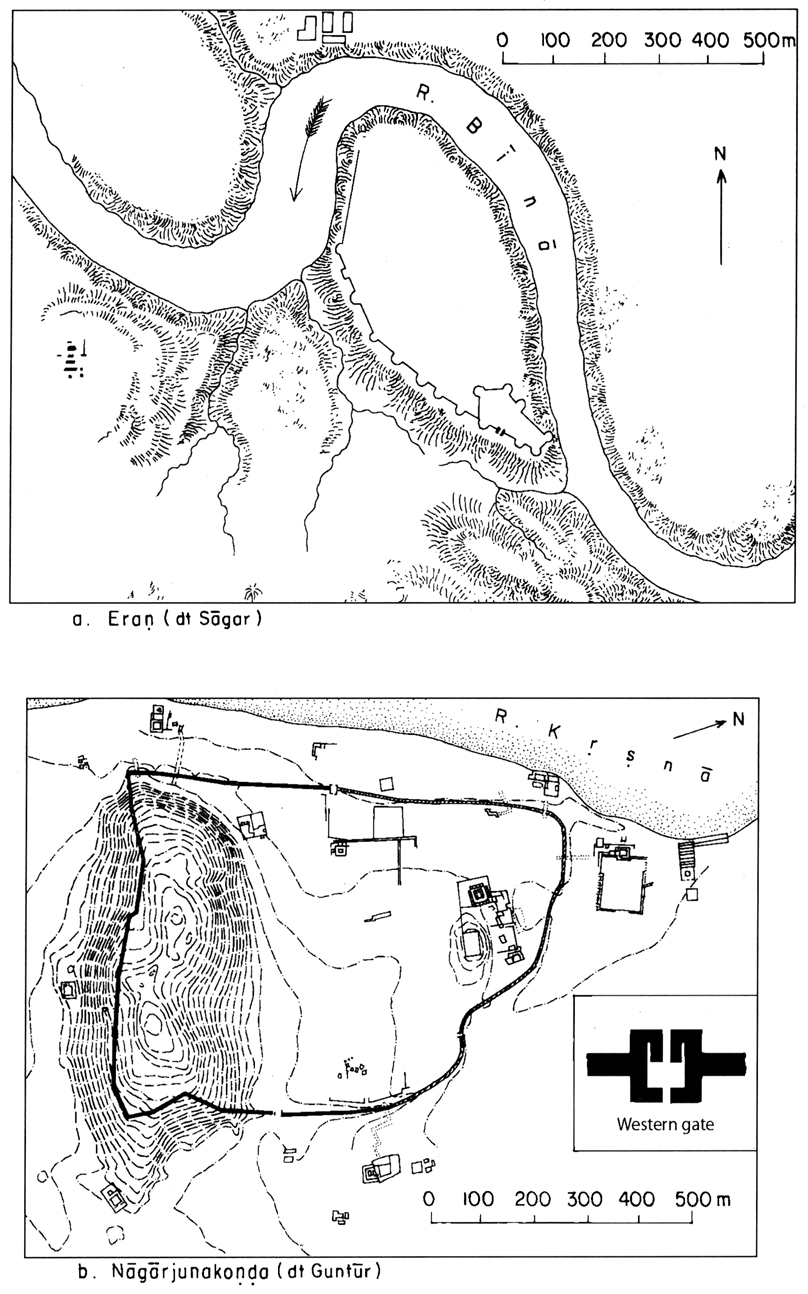
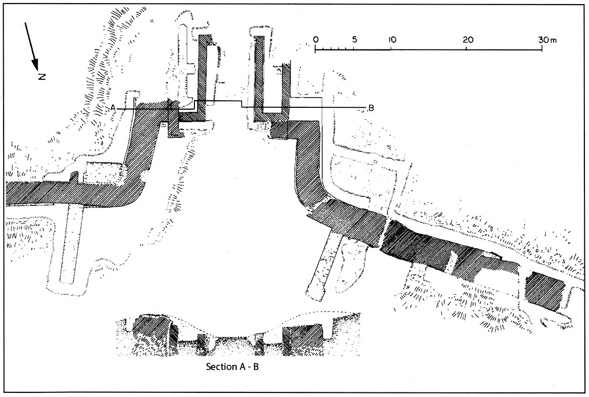